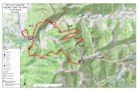
Clear weather after a cold front with some rain overnight allowed accurate mapping of the wildfire. Clear, drier and windy conditions are present. Aircraft and helicopters are in operation.

Via email dispatch: "Today, work will continue on the fireline, including determining the best approach for containing the fingers that run into Shovel Creek. Mop-up of the spots across 14-mile Trail should be finished today, as well as structure protection work. Crews will continue securing the perimeter in the following priority areas: Shovel Creek, 14-mile Trail (Bennett Highway) and the northwestern flank across the Chatanika River. While the wet weather has slowed the fire’s movement, it is also slowing the firefighters’ work somewhat this morning. Firefighter safety is affected by poor footing, slick roads, and trees with burned root systems falling down in the winds predicted for today as a cold front passes. Clearing weather and improved firefighting conditions are expected this afternoon."
Text from this mornings situation report:
Fire has not been accurately mapped do to low visibility (likely closer to 12,000 acres). Fog hampered air ops. Structure protection is top priority. Portions of the Bennett Road will be burned out in the future to secure fire ridge. Finished direct dozer line on ridge between Hard Luck Creek from the Bennett Road to the Chatanika River. Prep for structure protection is done on Chatanika River.Finishing mopup of several slop overs off Bennett Road, working on slopover on Sovel Creek. Crews prepping Bennett Road for burnout.
Changes in statistics from yesterday:
* Total Personnel: 411 -> 387
* Percent containment: 0% -> 2%
* Total acres: 6500 (est) -> 13000 (accurate)
No comments:
Post a Comment