InciWeb updated at about Noon indicated containment at approximately 10%.
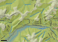
Goldstream Fire #160: Fire map shows MODIS detected hot spots (red squares) and reported location of fire. A fire extent will be available when they visually map the area from the air (possibly sometime Monday).

View from Lincoln Creek at 1 pm. Plume activity is greatly reduced. The overall forest fire season is long from over. Helicopter and plane activity can still be heard. This mornings report indicated that 125 staff are on the fire with more crews in route.
| Fire Name: | Moose Mountain |
| Daily Record For: | May 20, 2011 |
| Status: | S/U |
| Estimated Acres: | 700 |
| Incident Commander: | Blankenship, C |
| Personnel Count: | 125 |
| Daily Cost: | $72,000.00 |
| Summary: |
| At 1531 59633 reported a large column of smoke. Helitack arrived on scene and found 1/4 acre fire burning in black spruce 100% percent active in black spruce with trees torching. Air Attack, Retardant, Smoke Jumpers a Scoopers, Crews and Dozers were ordered for the fire. Surrounding VFD`s provided engines and staging was set up at Ivory Jacks. Fire operations will continue thru the night. IC + 124 |
| Fire Year: | 2011 |
| Sequence #: | 160 |
| Estimated Acres: | 700 |
| AFS Code: | F3Z1 |
| DOF Code: | 111160 |
| USFS Code: | PNF321 |
| Total Cost: | $72,000.00 |
| Structures Threatened: | 0 |
| Structures Burned: | 0 |
| Management Org.: | DOF |
| Office: | FAS |
| Option: | Critical |
| Latitude: | 64.94775 |
| Longitude: | -147.9311667 |
| Origin Owner: | BOR |
| Origin Admin Unit: | BOR |
| Discovery Time: | May 20, 2011 3:49:00 PM |
| Discovery Size: | 0.3 |
| Initial Behavior: | Rank 6 |
| Primary Fuel Type: |
| Mixed (Hardwoods/Softwoods) |
| Fire Type: | Unknown |
| Specific Cause: | Unknown |
| Origin Slope: | 0-25 |
| Origin Aspect: | Unknown |
| Origin Elevation: | 501-1500 |
| Township: | 2N |
| Range: | 2W |
| Section: | 33 |
| Quarter: | SESE |
| Meridian: | Fairbanks |
| Updated: | May 21, 2011 |
 Goldstream Fire #160: Fire map shows MODIS detected hot spots (red squares) and reported location of fire. A fire extent will be available when they visually map the area from the air (possibly sometime Monday).
 View from Lincoln Creek at 1 pm. Plume activity is greatly reduced. The overall forest fire season is long from over. Helicopter and plane activity can still be heard. This mornings report indicated that 125 staff are on the fire with more crews in route.
No comments:
Post a Comment