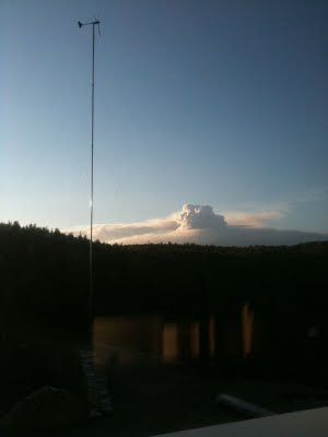
A cold front cleared out the air, but didn't produce much rain. These pictures are from June 6th, 2011 at 9 pm Alaska time showing new smoke plumes over the forest fire.
These new plumes indicate additional area has burned. We will find out tomorrow what burned. Over 550 personnel working on this fire.
| Fire Name: | Hastings |
| Daily Record For: | Jun 5, 2011 |
| Status: | S/U |
| Estimated Acres: | 12019 |
| Incident Commander: | Tom Kurth |
| Personnel Count: | 563 |
| Daily Cost: | $676,282.00 |
| Summary: |
| Continuing warmer temperatures and lower RHs led to increased fire behavior. Strong Southwest winds caused the fire to grow NE toward Hayes Creek Subdivision.Aviation assets assisted with slowing the fire`s growth along the east flank. Dozers worked their way down the ridge from Hayes Cr. to the fire`s edge and continued constructing contingency dozer line. Boats are assisting with structure protection on the Chatanika River. Preparations continue in the McCloud subdivision and along Old Murphy Dome Road. Dozers will continue constructing contingency lines east of the fire. Crews will continue constructing direct line on both the west and south flanks. Structure protection efforts will continue along the Chatanika River. Crews will continue structure protection efforts in Hayes, McCloud, and Desperation Loop. |
| Fire Year: | 2011 |
| Sequence #: | 271 |
| Estimated Acres: | 12019 |
| AFS Code: | F4D8 |
| DOF Code: | 111271 |
| USFS Code: | PNF4D8 |
| Total Cost: | $2,883,102.00 |
| Structures Threatened: | 1405 |
| Structures Burned: | 2 |
| Management Org.: | DOF |
| Office: | FAS |
| Option: | FULL |
| Latitude: | 65.0333328 |
| Longitude: | -148.3500061 |
| Origin Owner: | Unknown |
| Origin Admin Unit: | Unknown |
| Discovery Time: | May 30, 2011 11:45:11 PM |
| Initial Behavior: | Rank 5 |
| Primary Fuel Type: |
| Mixed (Hardwoods/Softwoods) |
| Fire Type: | Lightning |
| Specific Cause: | Lightning |
| Origin Slope: | 0-25 |
| Origin Aspect: | Unknown |
| Origin Elevation: | 0-500 |
| Township: | 002N |
| Range: | 003W |
| Section: | 7 |
| Quarter: | SWNW |
| Meridian: | Fairbanks |
| Updated: | Jun 5, 2011 |


No comments:
Post a Comment