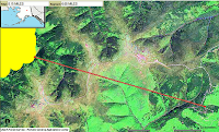
The fire crews are installing fire lines to form containment barriers around the fire. The past wet weather has helped efforts. Updates are generally available once a day. The fire has grown slowly to approximately 6500 acres. Mapping of the burned area has been difficult due to the large amount of smoke. Updates will be posted when they become available.
The yellow areas are hot spots that were detected by satellite before the rainfall. No additional hot spots have been detected for a couple days now. The distance from the edge of the detection to our property is about 8 miles. Exact information is difficult to obtain. Once the fire is mapped, we will get a better estimate. We have been told that the border is within 5 miles.

No evacuations are in place, however an evacuation plan is being deployed for the area.
Here is an older depiction of several outlines of fires nearby for comparison: (the red outline is the mapped fire boundary; the blue borders are temporary flight restrictions to allow water tankers and helicopters to attack the fires)

No comments:
Post a Comment